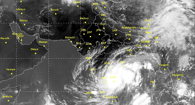
Depression could intensify into a cyclone close to Chennai, AP
Updated by admin on
Wednesday, May 18, 2016 12:08 PM IST

Chennai:
The depression over South West Bay of Bengal moved northwards in the last six hours and lay centred about 90 km east of Chennai and 70 km from the coast. Metmen have warned that this could intensify into a deep depression or even a cyclone. The system is likely to move north - northeastwards and intensify into a deep depression and further into a cyclonic storm in during next 48 hours, the Met office said in a special bulletin on May 18.
Regional Meteorological Centre Director S. Balachandran told mediapersons in Chennai that the depression could intensify into a cyclone.
Balachandran said there would be heavy to very heavy rainfall over the next 24 hours in Chennai and suburbs, Thiruvallur and Kancheepuram district.
Warning:
(i) Heavy Rainfall Warning:
Rainfall at most places with heavy to very heavy falls at a few places with isolated extremely heavy falls over north coastal Tamil Nadu & Puducherry during next 24 hours. Rainfall at many places with Isolated heavy falls likely over south coastal and interior Tamil Nadu during the same period. Rainfall at many places with heavy to very heavy rainfalls with isolated extremely heavy falls over south Andhra Pradesh coast during next 48 hours. Rainfall at many places with isolated heavy to very heavy falls likely over Rayalaseema and isolated heavy over coastal and south interior Karnataka during the next 48 hours.
(ii) Wind warning:
Squally wind speed reaching 55 - 65 kmph gusting to 75 kmph would prevail along and off north Tamil Nadu & Puducherry during next 24 hours and south Andhra Pradesh coasts during next 48 hours. Squally wind speed reaching 40-50 kmph gusting to 60 kmph would prevail along and off Kerala and Lakshadweep during next 48 hours.
(iii) Sea condition along and off north Tamil Nadu, Puducherry and south Andhra Pradesh coasts:
Sea condition would be rough to very rough along and off north Tamil Nadu & Puducherry and south Andhra Pradesh coasts during next 48 hours.
Heavy rains have once again started to lash Chennai and while there were squeals of joy in the beginning, torrential rains soon reminded people of the 2015 incident which had left them helpless. The city recorded 71 mm of rain on Monday and surpassed the monthly average rains in 21 hours itself.
On Tuesday, rains were more intense and the city recorded a whopping 66 mm in just a span of 12 hours between 8:30 am and 8:30 pm. In fact, the city has recorded 101 mm of rain in just a span if 21 hours, soon the city is expected to break its all-time record anytime soon.
The weather system which has been responsible for these intense rains intensified into a depression yesterday. Weather models indicate its further intensification into a deep depression. Last night, the system was centred 120 km south-southeast of Chennai.
As the weather system has moved closer to Chennai, heavy rains are expected to lash Chennai during the next 24 hours. In fact, both rainfall intensity and spread will increase significantly during this period. It is advisable for residents to move to safer areas. Many people have complained of water logging in their areas. As per weathermen, flooding rain is also possible over many areas which will remind people of Chennai floods of 2015.